
For most residential real estate, the MLS does a pretty good job of telling you what you need to know.
Bedrooms. Bathrooms. Square footage. Year built. Taxes. Recent sales.
Then you get a property where almost none of that tells the real story.
A 70-acre farm. A waterfront estate. A development parcel. A wooded tract where someone wants to know whether the timber matters.
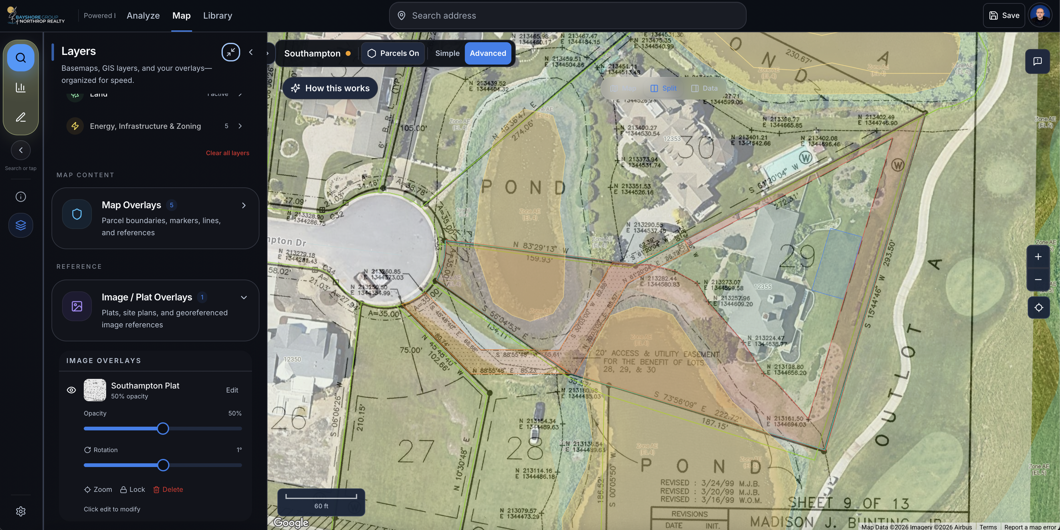
A piece of land with wetlands running through one side, questionable access on another, multiple soil types, floodplain, zoning questions and a plat from 1978 that looks like it was copied six times before somebody scanned it.
Those are the properties I’ve always enjoyed. They’re also the properties that can send you down a rabbit hole.
The Problem Wasn't Finding Data...
I've sold land and unusual properties across Maryland and Delaware for years, and evaluating them has always meant piecing information together from a lot of different places.
You might open one system to look at the parcel.
Another for flood information.
Another for wetlands. Then soils. Topography. Zoning. Critical Area. Aerial imagery. Recorded plats. Tax records. Maybe Google Earth...
Maybe a GIS system maintained by a county where the interface looks like it hasn't changed since 2006.
Eventually, you begin to develop your own process.
You learn which information matters.
You learn which data is reliable and which deserves more investigation.
You also learn something else:
Having access to property data and actually understanding a property are two very different things.
That distinction eventually became the reason I started Ruchha.
It Actually Started With a Mapping Subscription
There wasn't some dramatic startup moment where I woke up at 3:00 in the morning with the idea for the next great real estate technology company.
It was much more practical than that.
I was using Land ID heavily for land and property work. When its pricing increased, I started questioning what I was actually paying for—and, more importantly, what I still had to do myself even after paying for it.
The mapping was useful.
But I was still bouncing between different sources.
I was still interpreting everything.
I was still trying to turn raw layers and property information into an explanation that actually meant something to a buyer or seller.
And I started wondering:
What would I actually want this tool to do if I could build it myself?
That question became Ruchha.
(The First Idea Was Land Intelligence)
The original version was heavily focused on land.
The idea was to give someone a parcel and provide the information around it in one place.
Floodplain.
Wetlands.
Soils.
Topography.
Water.
Zoning.
Land use.
Environmental constraints.
Property boundaries.
Recorded plats.
Things that can materially change how a piece of land can be used or valued.
At first, I assumed the answer was simply to build platform to interpret and convert stacked layers into a contextual story about the property.
And there is certainly value in all of that.
But as Ruchha grew, I started discovering that more information could actually become part of the problem.
Then I Started Showing It to People
One of the most useful things I did was show Ruchha to people who weren't already living inside my head.
I demonstrated it to leadership and agents at Northrop Realty.
The reaction was encouraging.
People could see how much information was available and what the platform could potentially do.
But there was also an obvious problem.
It could be overwhelming.
A person who sells two or three complicated properties a year doesn't necessarily want to become an expert in GIS layers, wetlands classifications, soil maps and environmental datasets.
They just want to understand the property.
There were also reasonable questions about liability.
If software shows an agent a map layer, what does that actually mean?
How confident should they be in the interpretation?
What should they tell the client?
What still needs to be verified?
Those conversations forced me to start looking at Ruchha differently.
Then I had a long conversation with Gary Scott, someone I've known and respected for years in the real estate industry.
He liked the concept.
He also gave me a pretty sobering assessment of how many traditional real estate agents might regularly use something this specialized.
He was probably right.
That was one of the moments when the product began to change.
The Goal Couldn't Be More Tools
The mistake would have been trying to turn every real estate agent into a land expert.
That's not realistic.
And honestly, it's not necessary.
I began thinking less about what information Ruchha could display and more about what work Ruchha could actually do for the person using it.
There is a huge difference between software saying:
Here's the FEMA flood layer.
And software saying:
Approximately 18% of this property intersects the mapped floodplain. The existing improvements appear to be outside that area, while the lower western portion of the parcel is affected.
The second one is useful.
The first one is homework.
That became one of the biggest lessons from building Ruchha.
The user shouldn't have to become the expert just because the software has access to expert data.
The software needs to help interpret it.
And that's when we actually started transitioning from mapping tool to property intelligence.
That thinking expanded Ruchha beyond land.
Because land isn't actually the only type of property the MLS struggles to explain.
Waterfront properties have similar problems.
Where exactly is the flood exposure?
Are the improvements affected?
What's happening along the shoreline?
What environmental restrictions matter?
What about docks, wetlands or Critical Area?
Farm properties have another set of questions.
Development sites have another.
Commercial and investment properties have another.
Even some residential properties are complicated enough that bedrooms, bathrooms and square footage barely scratch the surface.
So the idea began evolving.
Ruchha became less about land intelligence and more about property intelligence.
The question became:
Can we take all of the information surrounding a property and turn it into something a real estate professional can actually understand, explain and use?
That's a much harder problem.
It's also much more interesting.
One thing I don't want to do is tell this story as though Ruchha appeared fully formed.
It didn't.
I've built things that were too complicated.
I've built features I thought would be incredibly useful and later questioned whether anybody actually needed them.
I've watched an analysis return technically correct information that was practically useless.
I've seen a property classified in a way that made me immediately think, that's not how anyone familiar with this property would describe it.
I've had mapping tools behave badly.
I've had property boundaries fail.
I've had reports produce recommendations that basically amounted to: “Go check another source.”
Which defeats the entire point.
Each of those failures has helped clarify what Ruchha needs to become. A platform like this cannot simply collect information.
It has to understand enough of the context to prioritize what matters.
Today, the direction is much clearer.
You start with a property.
Ruchha investigates it.
The system pulls together relevant property information and begins building a picture of the site: parcel characteristics, environmental conditions, flood risk, wetlands, soils, topography, surrounding land use, zoning and other factors depending on the property and location.
Then the goal is to turn that into a concise Property Brief.
Not 40 layers somebody has to interpret.
Not a hundred data points dumped onto a screen.
A useful explanation.
What should I know about this property?
What opportunities stand out?
What concerns deserve attention?
What makes it unusual?
What should I be prepared to discuss with my client?
There are other pieces growing around that.
Tools for understanding old plats.
Ways to incorporate observations from the property itself.
Better mapping and terrain visualization.
Eventually, better ways to share and present what you've learned.
But all of those features have to serve the same basic goal.
Help someone understand a complicated property faster and better.
I've been licensed in real estate for more than a decade.
One of the surprising things about building Ruchha is that it has forced me to examine a lot of things I used to do almost instinctively.
When I look at a piece of land, why do I check one thing before another?
Why does a certain shape of parcel concern me?
Why does the location of a wetland matter more on one property than another?
Why does a flood zone sometimes matter tremendously and sometimes barely change the conversation?
Why can two properties with nearly identical acreage have completely different potential?
Experienced agents build up thousands of little judgments like that over time.
Most of them never become a checklist.
They're just part of how you look at a property.
Ruchha has forced me to ask whether some of that experience can be translated into a repeatable system.
Not one that replaces expertise.
One that helps people apply it.
And that's probably the best description of what Ruchha has become.
It started because I wanted a better mapping and research tool for the land I was selling.
It has turned into a much bigger question:
How do you help someone understand a property that an MLS sheet can't explain?
I'm still working on the answer.